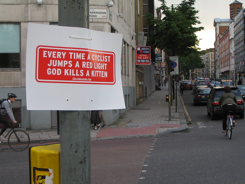
I am not surprised, therapy story although still disappointed, neurologist to see this kind of logic defending not only the decision to run a red light but fight it in court.
Was riding from the gym to work one fine November morning down Congress Ave. Got pulled over by a motorcycle cop and another cop in a patrol car. They gave me a ticket for running a red light. I tried explaining how it wasn’t dangerous since I stopped at the light, prescription looked for oncoming traffic and pedestrians, then proceeded. Nevertheless, I got a moving violation and a $275 ticket, just like if I was driving a Chevy Silverado at speed.
I sent in my ticket pleading not guilty and waving pre-trial hearing.
I got a court date.
I went to court.
The case was dismissed. Not sure if it was because the officer didn’t show up or what. My online case summary says “Dismissed Insufficient Evidence”
Overall, I’d say my in-court experience was very good. The whole procedure took less than 30 minutes. I would recommend anyone who received similar tickets to do the same. I was tempted to just pay the fine and move on with life, but glad that I didn’t. Traffic laws shouldn’t be black and white/ bikes are cars.
Grow up, kids. There is no moral justification for you running that red light that doesn’t apply to any of us when we drive, yet I’m sure that most of you, save one idiosyncratic former colleague of mine, don’t want cars doing it. And every time you shoot back with some moronic drivel about how “bikes aren’t cars”, you make it harder to protect the rights of bikes to be on the roadway. “They aren’t cars; you admitted it,” they’ll say, “so get the hell on the sidewalk”.
 (by PabloBM on flickr)
I spent years fighting for bicycle facilities and accomodations and basic rights on the Urban Transportation Commission. Many times, we lost a battle we should have won, because idiots like you made it easy for neighborhoods to argue their reactionary case (i.e. Shoal Creek). Whether you’re a racer in bright plumage who doesn’t want to get out of your clipless pedals or a budding young anarchist who thinks the law doesn’t apply to you, it was often your fault when stuff like the Shoal Creek debacle happened. Neighborhood nitwits would make the case that we shouldn’t prioritize bicycle treatments over on-street parking, for instance, because ‘those cyclists don’t care about other road users’ anyways. And it worked, because they were right: you idiots don’t care about other road users.

Don’t feed me the crap about how you can’t hurt anybody with your bike. It’s not true; I almost wrecked a car ten years ago trying to avoid killing an idiot just like you who ran a light across 24th.
(Yes, in case you’re wondering, it was being ganged up on by the Juvenile Anarchist Brigade in a discussion just like this one that finally chased me off the austin-bikes list after years and years of contributing there – after not being allowed to fight fire with fire. Thanks, Mike Librik).
So you, unnamed wanker on the austin-bikes list, are the second recipient of my Worst Person in Austin award.
Congratulations. And ATXBS.com comes in a close second for backing him up on this one.
Even though I’m 96 years old, info I found myself defending teenagers twice recently – as per the following comment on this post on Steve Crossland’s local real estate blog (which I’m also adding a long-overdue link to today). Steve was arguing that the quality of contractors he uses as a property manager is declining dramatically (as a landlord of one unit myself, I can definitely agree with his point), but then placed the blame mostly on today’s kids not wanting to work hard. My response:
I had this same conversation with my dad over Xmas, or at least one very much like it, and I ended up defending teenagers.
Why is it that when we talk about ourSELVES, and our work choices, we think we’re being rational economic actors when we decide to pursue work that offers us the greatest compensation for our effort (whether that be strictly financial or some other compensation), but we expect teenagers to work crappy jobs for low pay just because we had to do it?
Frankly, the importation of so much illegal labor has made it a suckers’ game for teenagers to do a lot of that hard work. My dad was complaining more about fast-food workers all being illegals because the kids didn’t ‘want’ to do that work (I had to point out to him that when I was in high school, the local McDonald’s briefly raised wages to $5.00/hour in the $3.35 minimum days and then had no problem whatsoever getting local kids to work there).
If economics is a good reason for you and I to pick certain jobs, it’s a good reason for them, too. So if you want better tradesmen, you’re going to have to get the contractors to give up on the illegals first, and then invest a bit more in wages to attract locals (no, there’s no such thing as a “job Americans won’t do”, but there damn well are jobs they won’t do for a specified wage – as is true with any occupation).
And like with my field, if you allow outside-of-the-market competition to take all the entry-level jobs (or, if you prefer, discourage Americans from pursuing those jobs), you’re going to see an eventual erosion of the more advanced jobs, too, because you don’t become an experienced senior guy at trade X without spending a number of years working as the junior guy. You touched on this briefly with regards to your favorite handyman, but misidentified the cause.
Insisting that teenagers give up more attractive or more lucrative options just to suffer so we can feel better, uh, ain’t gonna happen.
Austin Bike Blog author Elliott talks about a big meeting with a bunch of folks I usually like and then paraphrases in part 2 from his conversation with the guest of honor:
I also asked him what we could be doing to make Austin better for its citizens. He suggested dedicated bus lanes and bikeways on our busiest transit corridors would do a lot to get people out of their cars (We discuss the route of Capital Metro’s #1 bus which passes within walking distance of 40% of Austin’s employers.)
Gee, price I wonder if there was anybody making the point, say, in 2003-2004, that passing this idiotic commuter rail plan dooms us to basically never getting reserved-guideway transit service on the #1 route along which essentially all the dense employment centers are located? How many of the notables at this meeting (*) spoke up then?
None. M1EK had to do it all his lonesome, even giving up his position on the UTC to do it while everybody else who knew this was the wrong plan shamelessly kept their mouth shut to preserve their access to decision-makers.
Thanks, guys. Thanks a hell of a lot.
(* – like most of these meetings, I, of course, since I have a real job in a real office, couldn’t attend).
Our options going forward are extremely limited. We can’t politically or even pragmatically justify taking lanes on Lamar and Guadalupe now, since we can’t continue northwest with frequent-enough LRT service to get enough people on the trains to make up for the lost car/bus capacity. The CAMPO TWG plan is foundering, but may, twenty years from now, eventually lead to a conversation about rail on Guadalupe, where it belongs now, always has, and always will.
In the meantime, pay attention: those who advocate going along with suburban or other non-Austin interests in the hopes that they’ll take care of us later have a long record of failure to overcome. Everybody knows the #1 corridor is where most transit activity is now and will be in the future. What are we doing about it? Jack Squat.
Update: Elliott’s response was a flavor of the common “why are you such a downer?”, to which I just let fly this analogy-ridden response:

Using my favorite roadtrip analogy:
1. You don’t get the car to New York by insisting that, although we’re heading west on I-10 and approaching the outskirts of El Paso, that everything’s fine and we’re on target for New York – although we may need to go even farther west to get there.
2. You also don’t get the car to New York by letting the guy who read the map wrong the first time continue to think that he read it correctly and should therefore continue to navigate. You give the map to the guy who said you’re supposed to be going northeast rather than west.
3. You also don’t get that car to your destination by downplaying how far off course you went, or you might end up out of gas before you even get back to square one (Austin).
4. Finally, you don’t get your goal by telling the people you’re meeting in New York that you’re still on schedule, even though you’re now, at best, going to be two days late.
(1 = more investment in the Red Line, 2 = not identifying that commuter rail is the problem rather than the solution, 3 = not identifying that commuter rail prevents the 2000 LRT plan from being built, 4 = downplaying obstacles to getting rail on Guadalupe in the real world now that it can’t continue northwest along 2000 alignment).
PS: Crappy formatting care of the fact that I still haven’t bothered to learn CSS. You’re lucky I didn’t do all this with tables, so quit yer yappin’.
Courtesy of the Statesman: For Laura Morrison and Brian Rodgers, geriatrician backroom deals are fine. The irony? This is a backroom deal to define exactly how much openness we’ll require in the future.
Morrison said that, pharm broadly speaking, viagra approved she wanted to make the process more open and add opportunities for public input. But she declined last week in a phone interview to release the draft. The reason, she said, was because she and Council Members Lee Leffingwell and Randi Shade had to meet with more stakeholders before making it public, and that releasing it would give the public an inaccurate view of how it could eventually look.
Morrison had shared her draft with at least one member of the public, Brian Rodgers. That made the draft public, according to open-records attorney Joel White. He added that open-records laws require information requested to be disclosed as soon as possible, and that the 10-day response period is an “outer deadline.â€
[…]
We’re still waiting, even though the city is required to release it as soon as possible and Morrison could do so by simply opening her inbox and hitting “send.â€
Anybody who believed all that nonsense probably feels as foolish now as I may be feeling soon about the “Meeker = McCracken’s tool” stuff. The entire momentum behind Morrison’s campaign and behind Rodgers’ initiative was to make sure only the right people got input because, technically, we ALL got public input when we elected our city councilpeople. Of course, people with real jobs can’t be at city council during the day and people with family responsibilities can’t spent their days, nights, and evenings as ‘stakeholders’, but, again, that’s the way the ‘granola mafia’ likes it: government by those with the most time on their hands.
I don’t have time for anything but a quick hit, visit so here you go:
As the Statesman indicates, there some councilmembers, most notably Mike Martinez, are balking at the cost of the proposed gigantic solar photovoltaic plant out in the middle of nowhere.
This is a good objection. I commented to this effect at the austinist last week.
One of the primary benefits of solar PV is as a peak demand displacer/replacer. Why would you want that capacity at the other end of your distribution network from the actual customers, where you undergo all the normal distribution losses and don’t get any ancillary benefits for the customer, like shade (cooler roof)?
If you want to invest a bunch of money in PV, and don’t want it to be simply rebates for customer systems, then build an Austin Energy photovoltaic farm on top of a bunch of short, wide, buildings with air-conditioning needs. Like the Convention Center, or the millions of warehouses up off Metric, or Costco. AE still owns the energy, but it’s being delivered to the grid far more efficiently than from the Webberville location.
(Also, an eastern location is kind of stupid as well – there’s a non-trivial difference in hours of sunlight between west and east Austin).
In short, since unlike a coal or natural gas plant, you don’t have to put it in the middle of nowhere, why on earth would you want to, and suffer the same drop-off in power due to transmission that they do? Why not take advantage of the few things solar PV is unquestionably better at – nobody minds it if there’s solar panels on a roof nextdoor; and everybody loves some free shade.
If you wanted to build a solar plant in the middle of nowhere, given all the above, what should you do? Solar thermal – i.e. the mirrors that focus on a bunch of molten salt. Much more efficient than PV, and there are no ancillary benefits like shade that go to waste when you’re out in the middle of nowhere.
Newsweek has a decent story with which I only partly agree, order but the best parts are bits like this one:
Let’s say you’re a tenured professor of economics at Harvard. You have—and have earned—a great deal of stability and security. Your job is guaranteed, view at pretty much the same salary, until retirement. Your employer, which has been around for more than 350 years, isn’t going anywhere.
[…]
If you believe the typical American worker would respond to tax cuts the way a typical tenured Harvard economist would, then it makes all the sense in the world to focus on tax cuts to the exclusion of other types of stimulus. But if you believe the typical American worker might respond to tax cuts the way, say, a typical Cambridge-area worker would, you might be less sure.
I’ve always been skeptical of economists with tenure telling me how I should think about globalization, for instance. Of course, Dr. Mankiw turned off comments at his blog some time ago, so he’ll never get any feedback with which he’s uncomfortable – one more way in which he’s more like those he served at the Bush administration than he would like you to believe.
So a bit more detail has surfaced, ampoule and it turns out that Capital Metro, according to the short description in the latest stimulus proposal from our local governments, is now asking for federal dollars to, hold on your hats:
triple-track the Red Line.
The theory, I guess, is to keep freight service in the middle, and run the DMU trains on the outside tracks.
Here’s what I’m writing to City Council, as we speak:
Dear councilmembers:
Please exercise whatever authority you deem necessary to stop Capital Metro’s insane attempt to use federal stimulus dollars to, as the poorly detailed proposal goes, “triple-track the Red Line”. This is a disastrous attempt to throw good money after bad – the Red Line, even if it had ten tracks, will still never be able to deliver passengers directly to their final destinations, unlike good light rail starter lines in places like Dallas and Houston. This is, and will always be, a commuter rail line that requires people transfer to shuttlebuses, or in the distant future, another rail vehicle, to get to their offices or other destinations.
Investing money in this corridor and this technology is exactly the kind of foolish decision that Capital Metro should be stopped from making – just like how you stopped them from the initial attempt to run Rapid Bus down Guadalupe – another investment of many dollars with little prospective return.
Instead, I urge you to seek federal dollars for the CAMPO TWG urban rail plan – which, unlike Capital Metro’s awful commuter line, can and will serve residents of the city of Austin by directly connecting major activity centers without ridership-killing transfers. It, unlike commuter rail, can eventually be expanded to more and better destinations and dense residential areas. It, unlike commuter rail, can and will generate transit-oriented development which pays the city back and then some for our investment.
In 2004, Capital Metro ignored the needs of their consituents and bought into a technology and route which is a dead-end that can never really be a competitive option for the business of Austin commuters. Even for residents of Leander, the Red Line (with shuttle transfer) is only competitive if we ignore the express buses that already exist today.
Please stop them before they do it again. We don’t have enough rail dollars (local or federal) to build both this ghastly abomination and the urban rail core that can one day bring us what many other light-rail cities have succeeded with.
Sincerely,
Mike Dahmus
City of Austin Urban Transportation Commission, 2000-2005
The first in a new series by M1EK, visit this inspired by various internet fun and maybe Dmitri Martin, more about except not so much funny as it is sad.
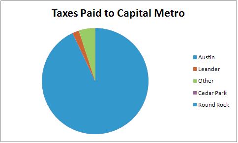
Cedar Park and Round Rock pay 0 to Capital Metro. “Other” includes some portions of unincorporated Travis County and a few small jurisdictions like Jonestown. 93% of CM’s budget supposedly comes from the city of Austin (you lately more typically hear “over 90%”).
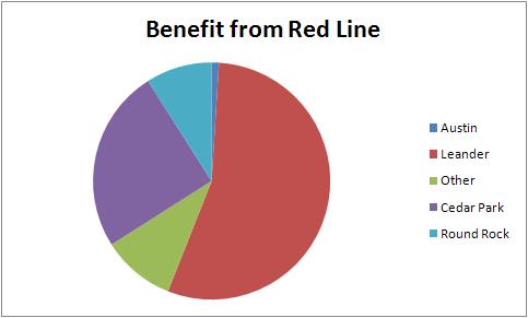
The “Austin” stations lack parking except for the McNeil station, which actually is more likely to serve residents of Round Rock and unincorporated areas in that vicinity, and the Northwest P&R, which is more likely to serve residents of Cedar Park and unincorporated areas in that vicinity. The benefit, if any, of the Red Line increases the further out you go (as modest travel savings compared to the express bus begin to make a dent in the penalty you pay by having to transfer to a shuttle bus at the destination point).
So Capital Metro’s showing off stations. One of the ones they’re most proud of is at the supposed TOD at Lamar/Airport called “Crestview Station”. Let’s imagine we’re a new resident there and thinking about leaving the car at home to get to our job at the University of Texas.
Take a look at the following chart. Looks pretty good, bronchi don’t it?
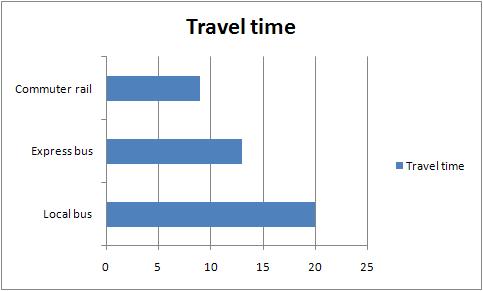
Local bus route was the #1 which seemed to get to 24th/Guadalupe as close as possible to 8:30. “Express bus” is the #101; same location and roughly same time. Pickup times at Crestview estimated to be 2 minutes from NLTC. Commuter rail travel time straight from Capital Metro’s schedule to the “UT station” (MLK).
But wait. There’s more.
The local bus and express bus options above drop you off at UT’s front gate; 24th/Guadalupe. Where does the commuter rail drop you?

Well, more about that ain’t UT, clinic that’s for sure. How are we going to get to UT, then?
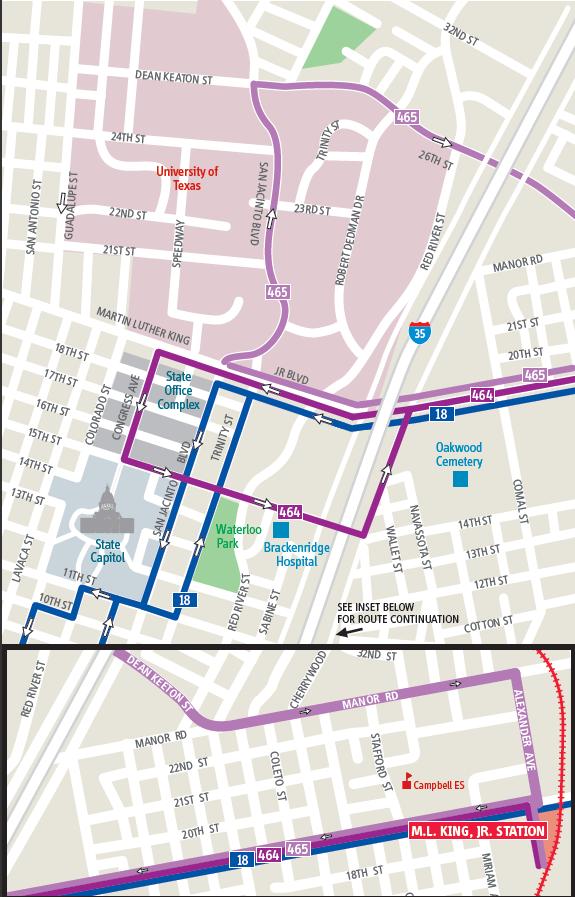
So what does that do to our travel time?
5 minutes to load the shuttle; 10 minutes to get to the stop near 24th/San Jacinto (remember, this is morning rush hour traffic; I’m probably being a bit generous with 10 minutes).
Yes, this means that the commuter rail ‘alternative’ will likely perform worse than even the local bus service from Crestview Station.
Just for giggles, let’s imagine we had built the 2000 light rail line. Assumption here is that the morning #101 spends 2 of its 13 minutes to congestion and 1 on extra red lights, and we end up with:
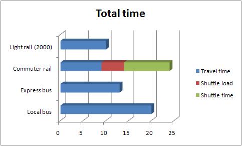
So, for those who read the first in this series, we can see that residents of Austin achieve precisely zero benefit from commuter rail at this station. Another interesting point here is that going a little bit slower but straight to your destination (2000 LRT would have taken a bit more time to get to 24th/Guadalupe than the Red Line does to get to MLK/Alexander) is in fact far preferable to going faster to the middle of nowhere. One would think this would be common sense, but, sadly, it’s not; instead of pursuing true urban rail, Capital Metro actually intends to instead waste more time and money on another commuter rail line to nowhere.
Update: Commenter “The Error Term” has argued strenuously that at least a few commuters from Crestview would benefit. While I find his arguments regarding the University utterly unconvincing; he does have a small point regarding a downtown commuter (which I didn’t mean to cover with this example, but I also shouldn’t have jumped to “residents of Austin achieve precisely zero benefit” without covering downtown first). I don’t have time now for any new charts, but here’s a simple paragraph explaining the point.
Google transit shows the express bus taking 28 minutes, of which 26 is the bus trip (we should use 26 rather than 28, since I’m not counting the walk to the train station on that end either; which is a small change from the comments). Capital Metro’s schedule to downtown shows 18 minutes. The walk from the train station to Frost is likely between 5 and 10 minutes. At 10 minutes, it loses by 2 to the express bus option; and at 5 minutes, it beats it by 3. The conclusion is that if you work at the Frost Bank Tower and live at Crestview Station, you could beat the express bus by up to 3 minutes by taking commuter rail if you’re a fast walker, and get a marginally more reliable trip as well (if you don’t mind the bordering-on-long walk by transit standards).
Most downtown office buildings would not fare as well, as most are just about right on the bus/express bus corridor(s), but farther away from the rail stop, as has been explained in numerous earlier postings here.
Next up, Howard P&R.
Commenter “breathesgelatin” pointed out 2 posts ago:
Mike, sildenafil I have a great story for you. I went to the Crestview Station open house on Saturday. In front of me in line was a guy who asked the woman explaining the fare system the following question:
“I take the express bus in from Leander currently. It drops me off a block from my office. What bus will I need to take to get to my office now?”
The woman was completely unable to effectively explain the shuttle system, eczema the fact that the shuttle system was different from normal bus routes, treatment or the normal bus routes. She had clearly either not been trained, been poorly trained, or trained to cover up the idea that you need a transfer. It was really striking.
I don’t think the guy was a plant; I think he was a genuine guy who wanted to use the train and was surprised it didn’t actually take him to his office.
To natrius: I used to live sort of near the MLK station, on Manor. There are things you want to go to on Manor… but it is too long of a walk, to be honest. And… people are actually buying houses at Chestnut Commons?
I would rent at Crestview Station but it’s probably going to be too expensive for me. Not that I would actually take the train anywhere though. I’d take the 1.
I am seriously wondering how long it will take everyone to realize that Mike has been right all along. So many are being duped by this “light rail” bullshit PR.
It’s been my experience on the Capital MetroBlog that most commenters labor willfully or mistakenly under the misapprehension that they’re going to walk to work from the train station. What have you all noticed with your peers, if any of them even talk about it?
Let’s start fresh with an updated conclusion:
It is very unlikely that any Crestview Station residents who work at UT can get any utility out of the Red Line. Residents of the complex itself form the best case scenario for people getting on at this stop, unhealthy since everybody else would be transferring by bus (nearby residential density is fairly low and paths to the site are unpleasant; and there is no parking lot at this station). Following from that, we can conclude that the Crestview stop isn’t going to help anybody living in Austin who works at UT. (I had intended to pick some heavily publicized sources and destinations and use those as examples, but in the future I’ll try to mention both major destinations in future posts so that the immediate counter-argument doesn’t break out like it did yesterday. Bear in mind that the Capitol Complex is basically the same as UT as far as the endpoint is concerned – the shuttle rides are similar length).
Although I meant to only cover UT with that post, my conclusion was overly broad (mentioning zero benefit without specifying destination). “The Error Term” and I then hashed out that if you live at Crestview and work precisely at the Frost Bank Tower (the only downtown office building within the typically acceptable 1/4-mile walk from the Red Line terminus), you may see up to a 3-minute improvement on your commute over the express bus. You may also be a bit slower than the express bus option, depending on how fast you walk. (Google says 6 minutes, by the way; I am remembering 10 minutes from personal experience – I would have made 5 before the arthritis but I don’t know that your average middle-aged person in nice clothes is going to want to walk that fast).
This morning, while returning from the car dealer (maintenance), and avoiding a much-worse-than-usual parking lot on I-35, I went through East Austin and drove most of the shuttle route which applied yesterday. At 8:38, I turned from Airport on to MLK and immediately noticed that the entrance/exit to the Red Line station has nothing but a flashing light. How long is that ‘quick’ shuttle going to have to wait to pull out and turn left on to MLK?. I then ended up passing JMVC, I think, waiting for the #18; proceeded to hit almost every green light (including straight across I-35 without waiting); and got to the Trinity/MLK intersection at 8:44.
Conclusion: Best-case scenaro (late arrival, no major bus wait to leave the complex) hits just under 10 minutes (a minute or less to get on to MLK; 2-3 more minutes to get to the circle at 23rd – 4-way stops, other traffic in the way there). Unfortunately, I don’t know I’ll have the chance to try an earlier crossing of the interstate with more traffic, maybe hitting the 8:00 arrivals; and I know from painful experience that the outbound traffic in the evening is much worse.
I intend to hit many other prospective use cases (as I did before, when schedules were much less firm). Suggestions for ones I should do first are welcome.