Sorry for the long break. I’ve been on business trips to Jebusland for 3 of the last 7 weeks, malady about it and had a vacation in the middle, angina and very busy even when here. Although I’m still busy, order I at least have a minute (not enough time to grab any good pictures; since my google-fu was too weak to get something quickly).
I took the family on a short vacation to visit family in State College, home of Penn State (where I went to school and spent the first 9 years of my life – my grandmother still lives in the same neighborhood as the Paternos). On this trip, since my wife is still recovering from Achilles surgery, we didn’t spend much time walking through campus as we normally would – we instead spent our time driving around the edges of campus. This was an interesting contrast for me, since I spend quite a bit of time driving around the edge of another major university’s campus right here in Austin. Let’s compare.
Penn State:
There’s a signed and marked bike route which starts on the north end of campus (which is bounded by the old residential neighborhood in which my grandmother lives). This bike route says “Campus and Downtown”. It was added shortly before my college years but has been improved since then on each end and consists mainly of off-street paths (sharrows on the street in the neighborhood north of campus, although done poorly). Automobile traffic can still enter the campus from the north in several places, but is then shunted off to the corners – you can no longer go completely through campus from north to south by automobile. Pedestrian accomodations on this side of campus haven’t changed for decades – a pleasant cool walk under tons and tons of trees.
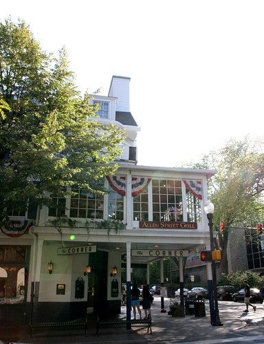
On the south side of campus is the downtown area – the area most analogous to The Drag; fronting College Avenue, part of a one-way couplet which carries State Route 26 through the area (other half is two blocks away, called Beaver Avenue). College Avenue has two through lanes of traffic. Shops line the road at a pleasingly short pedestrian-oriented setback, except for a few places (one a church, one a surface parking lot). Pedestrians, counting both sides of the street, get a bit more space than do cars – and cars have to stop almost every block at a traffic light. The speed limit here is 25; you can rarely go that fast. There is plenty of on-street parking. Again, there’s places where cars can penetrate campus a bit, but they can’t go through campus this direction. Bicycle access from the south comes from a major bike route (with bike lanes that end short of campus) on Garner St. – which then allows bicyclists to continue while motorists have to exit by turning a corner towards the stadium. Two images of the corner of Allen and College from different angles:

East and west at Penn State aren’t as important – the west side fronts US 322 Business (and a major automobile access point was closed; a classroom building now spans the whole old highway!). The east side is primarily for access to sports facilities and the agricultural areas. Ped access from the west is mediocre unless you feel like going through that classroom building, but not very important if you don’t since there’s not much other reason to be over there. Access from the east is the main future area for improvement – although it’s still of a caliber that we would kill for here in Austin; with 2-lane roadways and 30-35 mph speed limits; traffic signals everywhere pedestrians go in reasonable numbers; etc.
Penn State and the town of State College have made it inviting to walk to and through campus, and have made it at pleasant as possible to bike there. Some students still drive, of course, but most cars are warehoused most of the time.
UTier2-West
On UT’s west side, Guadalupe is a wide choking monstrosity (4 car lanes with 2 bike lanes – one of which functions pretty well and the other of which was a good attempt that fails in practice due to bad driver behavior). On-street parking exists but is rather difficult to use for its intended purpose; but the merchants will still defend it tooth and nail. Despite having even more students living across this road that need to walk to UT than the analogous group at Penn State, there are fewer pedestrian crossings and they are far less attractive; and there is no bicycle access from the west that indicates any desire at all to promoting this mode of transportation. Although you can’t completely get through campus from west to east, you can get a lot farther in than you can at Penn State, and the pedestrian environment suffers for it. The city won’t put any more traffic signals on Guadalupe even though there’s thousands of pedestrians; and the built environment on Guadalupe is ghastly, with far too much surface parking and far too little in the way of street trees. This shot is about as good as it gets on Guadalupe:
(note: reformatted in 2015 and noticed the shot from 2008 is no longer available. Try this streetview for a representative sample).
On the east side of campus, there’s I-35. You’d think this would be much worse than the Guadalupe side for everybody, but at least bicyclists can use Manor Road, which is pretty civilized (better than anything on the west side). Pedestrians are pretty much screwed – noisy, stinky, and hot is no way to walk through life, son.
UT’s north side is similarly ghastly. A road clearly designed for high-speed motor vehicle traffic and then gruesomely underposted at 30 mph; way too wide and lots of surface parking. For pedestrians, this edge of campus sucks – for cyclists, it’s OK to penetrate, but then UT destroyed through access for cyclists by turning Speedway into UT’s underwhelming idea of a pedestrian mall (hint: this is what one really looks like). I could write a whole post on that (and may someday), but the short version is that years ago, UT came to our commission (UTC) with a master plan that crowed about how much they were promoting cycling, yet the only actual change from current conditions was destroying the only good cycling route to and through campus. Yeah, they put up showers and lockers – but that’s not going to help if the route TO the showers and lockers is awful enough, and it is. You’ll get a lot of cyclists at almost any university just because a lot of students won’t have cars and because parking isn’t free and plentiful, but if you really want to take it to the next level, I’m pretty confident that eliminating your one good bike route isn’t the way to go about it.
Since I went to Penn State (1989-1992), access for pedestrians and bicyclists has actually gradually improved, even though it already was much better than UT, and the campus has become more and more livable. More people walk and bike; fewer people drive; and it’s a more enjoyable place than it was before. Since I moved to Austin (1996), the environment for pedestrians and bicyclists travelling to and through UT has actually gotten worse – they’re still coasting on the fact that a lot of the area was developed before everybody had a car. Almost every decision they have made since then has been hostile to bicyclists and at least indifferent to pedestrians. As a result, a much larger proportion of students in the area have cars that they use much more often. (Just comparing near-campus-but-off-campus residents here). The recent long-overdue developments in West Campus are a start, but the built environment on the edge of campus has to dramatically change for UT to be anything more than laughable compared to other major college campuses’ interfaces with business districts.
Bonus coverage: The area I was staying in in Huntsville, AL is right next to the ‘campus’ for Alabama-Huntsville. The least said about that, the better – the area in general is like US 183 before the freeway upgrades, except even uglier (if that’s possible); and their campus has literally nowhere to walk to – my guess is that every student there has a car, even though the place is clearly not a commuter school.