This has come up frequently in the past in regards to the idiocy of claiming that major retail belongs out on the frontage road (where I have claimed in the past that it’s impossible to practically provide good transit service). Here’s a much better version than my previous one, and as a bonus, MS Paint was still tangentially involved!
(For non-Texas readers who may have wandered in from Jeff’s excellent transit portal, almost all limited-access highways in this state are built from pre-existing major arterial roadways – where property access is maintained via the construction of new “frontage roads” which unlike perimeter roads often used for that purpose in other states, also serve as on-and-off-ramps. The incredibly wide road footprint that results makes it far more expensive to build new or maintain existing crossings over or under the highway).
Both images from google transit; click through for full details. This is basically the “how do I get from the drop-off for the express bus at the park-and-ride on the west side of the road to the entrance to all the office parks on the east side of the road”. Note that the address for the park-and-ride you sometimes get (12400 Research) doesn’t match the actual location, which is on Pavilion Boulevard back towards Jollyville.
First, the transit directions, which look pretty good at first:
![]()
Then, the driving directions, which look like this:
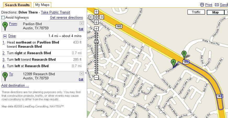
Huh. Wait a minute. If I can just jump across the road, why do the driving directions have me go down a mile and back? Let’s look at the satellite image (click to embiggen):
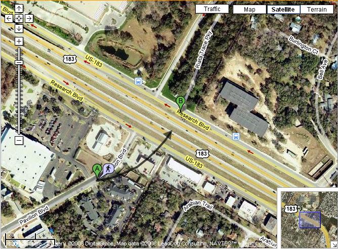
(Get more current satellite view here)
Oh. Now I see. Note that the bus stop images you see on the other side of the road are for a poorly performing cross-town route which suffers from the same basic problem – if you need to leave an office on that side of the street and go southbound on 183 back home, you get to walk to the next crossing – which on a normal street wouldn’t be that big of a deal, but crossings of frontage roads are few and far between. Farther to the northwest, crossings are even less frequent – you face a walk of close to 3 miles in spots to make this trip across the freeway. Taking that cross-town route would be even worse than taking the express plus the incredibly long walk, because it would require a long slow trip down the frontage road and then a transfer to a second bus, and because the service on the frontage road is inevitably low-demand, it doesn’t run very often either.
Keep in mind that this is just to cross the freeway. If you work at the Riata office park, you then face another walk of a half-mile or so inside the complex. I used to do this commute on my bike, with bus boost in the morning at times and am very familiar with the area – ironically, proximity to the Pavilion transit center was supposedly touted as a positive for this development when it was originally proposed. I was always pretty sure Pavilion used to connect with what is now called Riata Trace Parkway when 183 was just a six-lane divided arterial but have never been able to find a clear enough old satellite image to confirm, but our Tennessee correspondent has already confirmed in comments that it did cross.
For reference, my last job before this one was also on US 183, but between Balcones Woods and Braker Lane, which was much more accessible by transit – and yes, I did sometimes take the bus even on days where I wasn’t biking. I tried the bus commute once to Riata and never did it again – that walk, in addition to being far too long even for a nice comfortable express bus, is just dreadful, even compared to conditions down by Braker.
And, yes, there’s a personal reason this is coming up now too. All I can say now is dammit, dammit.