Lie #1 during Phase 1 of Project Connect was the justification of the collapsing of the West Campus and UT “subcorridors” (zones) into the Core subcorridor/zone “so we could ensure they would both be served by any initial alignment”.
At the time, on November 1st, I made this post, which asserted that there was no way this decision was being made to ‘serve’ West Campus; that, in fact, it was being made to avoid having to serve West Campus (which would obviously imply a route on Guadalupe).
Now, the final alignment through campus has been decided. Let’s see what we got. Click on most of these to make them bigger.
From Project Connect’s presentation to the CCAG on Friday February 21st:
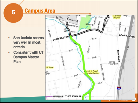
Huh. Look at that. Not only do we not even see West Campus, but we can’t even see the western half OF campus. What a shock!
But it’s probably just a misleading image, right? There’s no way Project Connect would have told everybody they were going to serve West Campus and then not do so – West Campus must be just right underneath the words on the left, right?
Let’s see how far away a couple points on San Jacinto are from a location two blocks west of Guadalupe, using Google Earth. (The center of density in West Campus is not on Guadalupe – the best height entitlements are actually several blocks to the west. A ‘population center’ of West Campus in a few years will likely be 3 or 4 blocks west of Guadalupe; so me using 2 blocks is being generous to Project Connect).
Remember that the rule of thumb in transit planning for years has been that most people will not regularly walk more than a quarter of a mile from their home to their transit stop (or from their transit stop to their office). A few will do more, but the quarter-mile rule ensures you will get most of your possible transit market. Some people lately have tried to assert that good rail transit can do the same thing with a half-mile walking radius; in my opinion, this works in some cities where parking is quite difficult, but primarily on the home end of the trip, not the office end.
First, from 21st and San Jacinto to two blocks west of Guadalupe on 21st:

0.6 miles. The main density of West Campus is definitely not served by San Jacinto even by the most generous standard. Guadalupe itself is 0.48 miles away; served only barely by the most generous standard. In other words, the side of campus with the most activity is well outside the commonly accepted walking radius and just barely inside the most generous one.
Now let’s try 24th.

0.58 miles to where West Campus’ density starts. West Campus is not served at all by a stop here, either.
Finally, Dean Keeton and San Jacinto:

Nope. 0.54 miles to the start of West Campus’ density. To the start. Still outside even the most generous reading of “served”.
Project Connect, the claim of yours made back in November is still a lie.
