A photographic exercise by M1EK. All pictures obtained from the 9/24/05 Future Connections steering committee presentation.
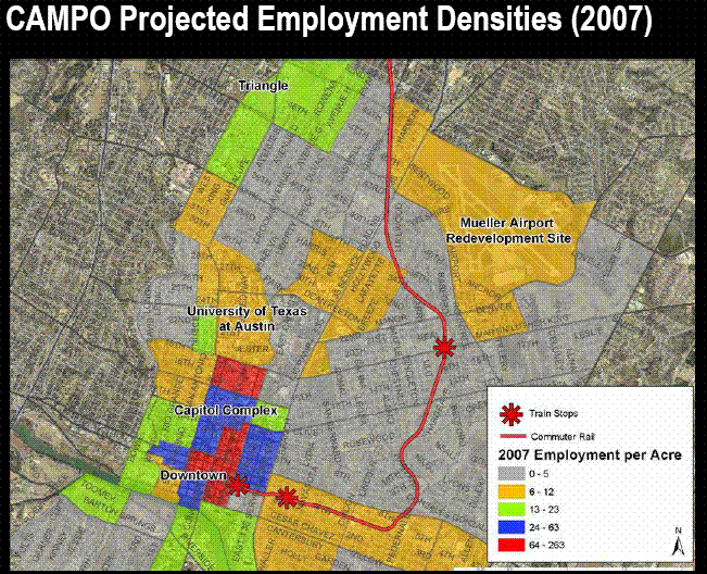
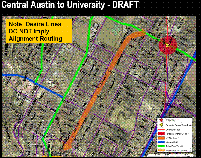
This is a bit misleading since it makes it look like Hyde Park and the neighborhoods around Airport Blvd are equally suitable for rail transit – the problem is that you can’t walk to stations along Airport from any residential developments of consequence; the area is fairly pedestrian-hostile.
Note that all of the existing and future high-density residential and employment centers are going to be served by “high-frequency circulators”, i.e., shuttle buses stuck in traffic. While the incredibly important Airport Boulevard corridor gets rail. Here’s one example of a circulator movement they envision; this one is planted right on Speedway near my house. Note: there’s already high-frequency bus service to campus and downtown on this street, so it’s doubtful they’ll be doing anything here other than publicity:
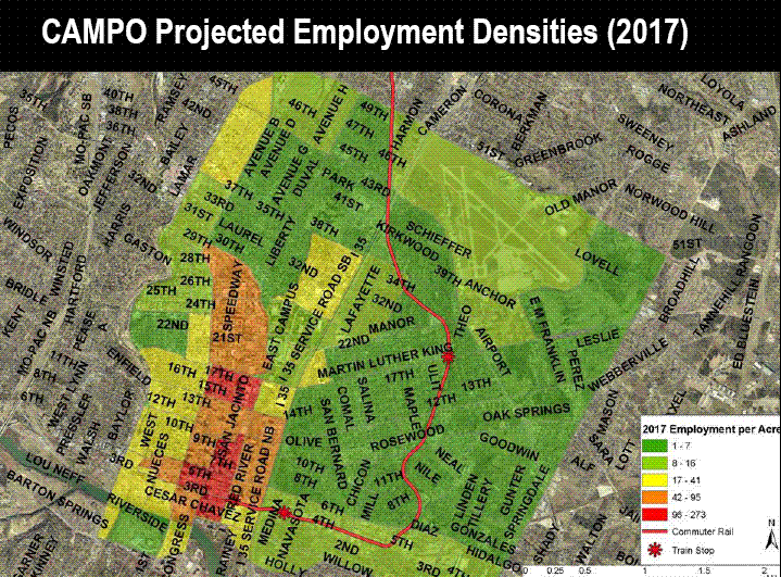
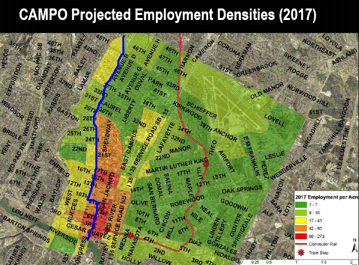
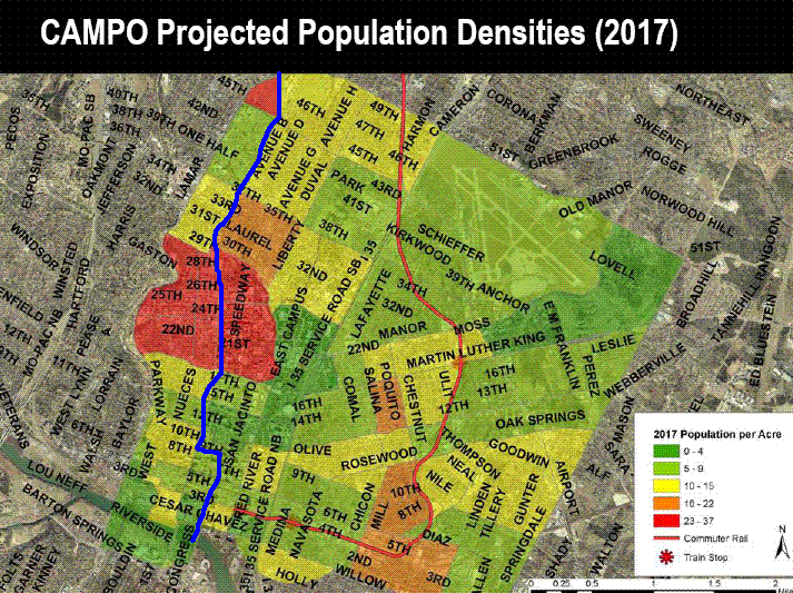
Now, for comparison’s sake, I took the two 2017 maps, and using my awesome drawing skills, drew the 2000 light rail proposal, in blue. The jog from the Guadalupe corridor over to Congress Avenue might have happened as far north as 11th; I chose 9th as a compromise. Some versions even had it running around the Capitol on both sides — but this is a simpler drawing that still hits all the same major spots. A short distance north of this map, the 2000 light rail line would have converged with the red “All Systems Go” line and continued northwest on existing rail right-of-way towards Howard Lane, so this picture captures most of the “difference” between the proposals.
Gosh, which one would have a better chance at delivering ridership? I really can’t tell the difference. I guess Lyndon IS right – this commuter rail plan IS just as good as light rail!
I remain very frustrated. Designing and implementing transportation strategies is an engineering discipline. You perform traffic studies and poll driving patterns and then plan routes and schedules that maximize usage. You can design the zoning ordinances to help evolve a corridor for it.
I think we are missing an opportunity here as we are building tons of highway projects without adding any room for light rail along side any of them. It will cost more later to add it back in and you will have construction congestion again. I am not saying you have to lay the track and start the service now, but at least have the infrastructure in place for when you do.
The other alternative is that Austin becomes Houston with six lane highways and hideous interchanges like 183 and 620. Picture Beltway 8 and I-10 on Houston’s West side.
“Designing and implementing transportation strategies is an engineering discipline.” In the magical world of make-believe, yes.
In Texas, designing transportation strategies is a matter of a road-centric TxDOT doling out corporate welfare to Texas construction companies (perhaps the fact that streetcars are not manufactured in Texas has something to do with their scarcity here). Implementing those strategies is a political process.
Mike, I suspect the Red line boosters don’t care what the current population projections show, because they’re probably TOD true believers. That’s really what this all boils down to – does build-it-in-the-middle-of-nowhere-and-they-will-come TOD work, or not? These people are being given two to three years of Cap Metro’s scarce project income to toy around with something that only worked in the early days of the national railroads 100 to 125 years ago, and not since.
How did we get to this point? In the case of the Red Line , we’ve been let down by the very people who should have been skeptical about the claims made by the Red line backers. If someone in Austin with power had raised a stink about this years ago when the plans were being drawn up, I don’t think it would have reached this point. I cast the most of the immediate blame at city council and at the Austin Chronicle. Both have been mostly indifferent about transit issues. Look at how many years Cap Metro was allowed to fester as a corrupt agency in the 90’s before it was finally overhauled. The council and the Chronicle helped bring us to this point, and I don’t see the stirrings of change yet.
Now that the thing is going to be built, the ultimate problem is the CAMPO straightjacket that I think is meant to keep Austin down. As you know from your own experience, Cap Metro/CAMPO/UTC is a tightly-woven good-ol-boy network. Even if you could get city council on board, there’s still the rest of the CAMPO members to overcome. Maybe we should be focusing on how to get Austin out of CAMPO. Yeah, I know, good luck with that, since it’s a state-chartered agency (and lookie who runs the state these days). Still, I think it’s worth considering. With CAMPO out of the way, Austin could start using its federal transport dollars to pay for local roads, and maybe *gasp* help fund LRT in the part of the town that actually needs it.
Now that I think of it, maybe a better plan would be to use all of the current anti-toll sentiment to get CTRMA abolished and get Mike Krusee booted out of the Lege, now that his puppet Tom DeLay is on the outs.
Sorry, that should be “now that his puppetmaster Tom DeLay is on the outs.”
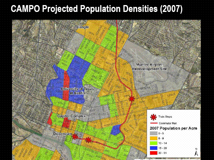
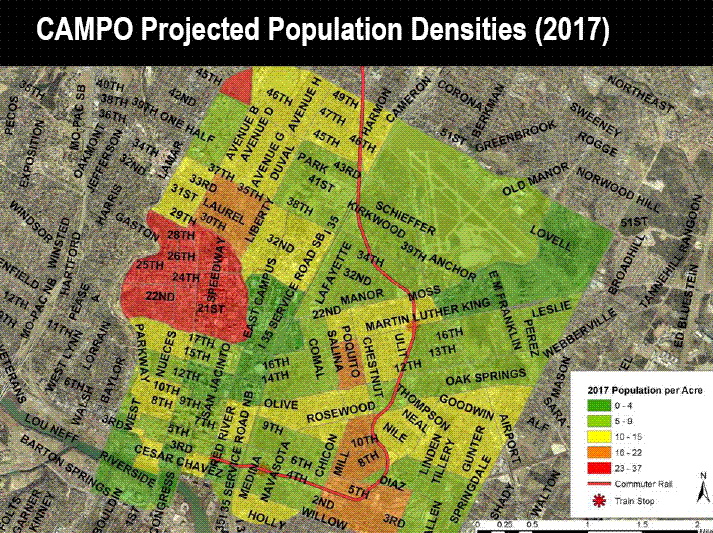
There are a few items to remember when you take a look at these maps. These are projections of how density will hold in the future. The main problem that these maps do not take into account is that there is development being planed because the line is being put in. There are several projects to move high density housing into East Austin as the rail line is put into use. These projections most likely do not take in to count the new renovations to the area.
Also this will not be the only rail line that is put into use. There are 4 more plans for additional rail lines running around Mopac, to the old Seaholm plant and area the UT campus. These lines will also affect the density of the environments around them.
And finally, the city is using this rail line to improve density. They have chosen medium to low density areas, so that high density development would move into the area and bring better density to Austin’s city center. When you take this into account the lines stops placement does not seem so out of place.