In the last several weeks, many people, most notably Central Austin CDC, have pointed out a series of errors in the “Map Book” presented as data in various public meetings by Project Connect. I myself found and commented on several at a public meeting downtown, which seemed designed to make the Mueller route look far more attractive than the facts would merit.
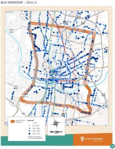
But the most egregious ‘error’, by far, though, was apparently discovered a day or so ago by Jace Deloney and then confirmed by the CACDC. It has to do with the “here’s how many people currently board the bus at various locations” map, which is a key baseline for anticipated rail ridership (which is, quite frankly, the most important map of all).
First, let’s see the Project Connect version.

If you were a novice to civic affairs trying to make up your mind, or a city staffer or council member who doesn’t ride the bus and trusts the information they’re receiving, this map makes it look like bus ridership in the Guadalupe/Lamar corridor is of roughly the same magnitude as currently exists in the corridors heading out to Mueller. But if you read this blog, or spend time on the Lamar/Guadalupe corridor, you would tend to think that can’t possibly be right, could it?
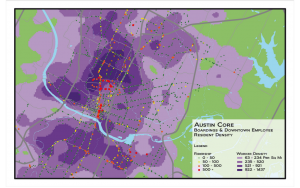
Well, it’s not. They left out the ridership from the #1L, the #1M, and the #101; three little routes that between them comprise the most heavily used lines in the entire Capital Metro system at 17,000 boardings/day. 8.5 times the boardings achieved by the Red Line, by the way. Oops.
Here’s a more accurate depiction of ridership, courtesy of Jeff Wood in a blog post last year:

With an error this egregious, one might expect an IMMEDIATE response like “this is unacceptable. We’re going to pull the maps and do them all over again.” If, that is, you cared about giving the correct data to support an actual data-driven decision-making process, and it had been an actual error; rather than, oh, I don’t know, a willful continuation of past transparent attempts to mislead people into thinking Lamar/Guadalupe isn’t worlds ahead of Mueller in terms of existing and potential ridership.
The only actual response from people at Project Connect, so far, at the time this post was written 24 hours later, has been this one response in two tweets immediately after being confronted for the second time yesterday:
Friend-of-the-blog JMVC was asked on twitter and just said he’d look into it. 24 hours later, and nothing’s been heard from either party.
Yes, you heard right. It’s just a minor issue of the 2011 ridership being “less complete”. Yes, leaving out the top line(s) in the city on this map, but somehow leaving in the lesser ones, was just a minor blip.
If you want to do something about this – tell your city council member that you see what’s going on, and you don’t approve of the wool being pulled over your eyes by people who are supposed to be giving us the data to make an educated decision about what to pursue. Or sign yesterday’s petition. Or both. I’m going to SeaWorld.
Update – let me frame this more clearly: Either:
1. This is a ‘mistake’ and the people at Project Connect and Capital Metro think it of so little importance that they view it as just ‘incomplete data’, which calls into question their judgement, their commitment to the process, and, frankly, their intelligence; OR
2. This is not a ‘mistake’ but a ‘plausible deniability’ kind of scenario, and the fix is in (as I’ve thought with some of the other map issues I’ve brought up with them).
Note that others’ feedback about the map issues they’ve found has resulted in zero information back (not even confirmation) over the past few weeks from Connect Central Texas. Zero. This, in what’s supposed to be a transparent, open, public, data-driven, process. So it’s not just mean old M1EK with his crazy crackpot ways getting this treatment. Bear that in mind.

