In honor of 2024’s Bike To Work Day1, I present a long overdue (pictures taken a couple months ago) segment: E 51st St at Tilley.
Fourth installment in the 2024 Bike Facility Roast N Toast series.
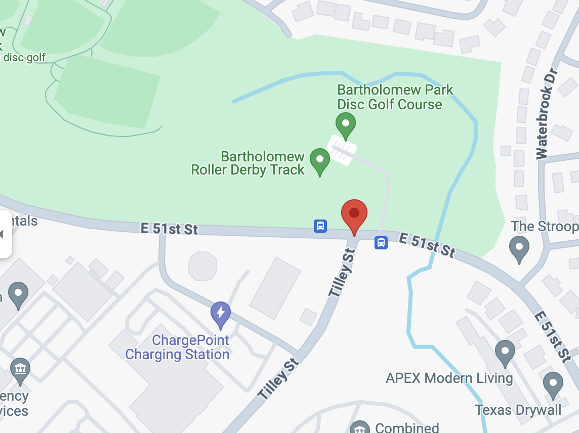
Location: On East 51st St, just east of the part of Mueller most people think of, at an intersection with Tilley St on the south end, and Bartholomew Park on the north end. Uphill on the westbound (north) side, downhill on the eastbound (south) side.
Implemented: ~2021 (based on historical street view images)
Type: Red sidewalk to move around bus stop on the north side, red sidewalk to cross Tilley St on the south side, transitioning to/from normal painted lanes on either side of the red sidewalk.
Context: Bus stop treatment and supposedly protected intersection treatment
Prediction when installed: Oh no.
Experience as a cyclist: (See below).
Orientation map, from our friends at Alphabet:
This is a type of facility treatment that’s becoming the default here, and this is a good example of “think about the context”, because honestly, this has one good side and one awful side, and it’s not going to be what you think.
The locational context: Useful today primarily for commuters and for people trying to get to/from the Southern Walnut Creek Trail. The intersection at Tilley isn’t that busy and neither is the bus stop. This intersection will hopefully see more kid/inexperienced travel across 51st to get to/from Bartholomew Park in the years to come.
First, the westbound (uphill) side, looks like this (from Google street view; I have not taken a picture from this vantage). On a lot of my recreational rides and an occasional “add ten miles to the work trip home” run, this is the last big uphill, so I’m going pretty slowly. Here’s what it looks like approaching from the east:
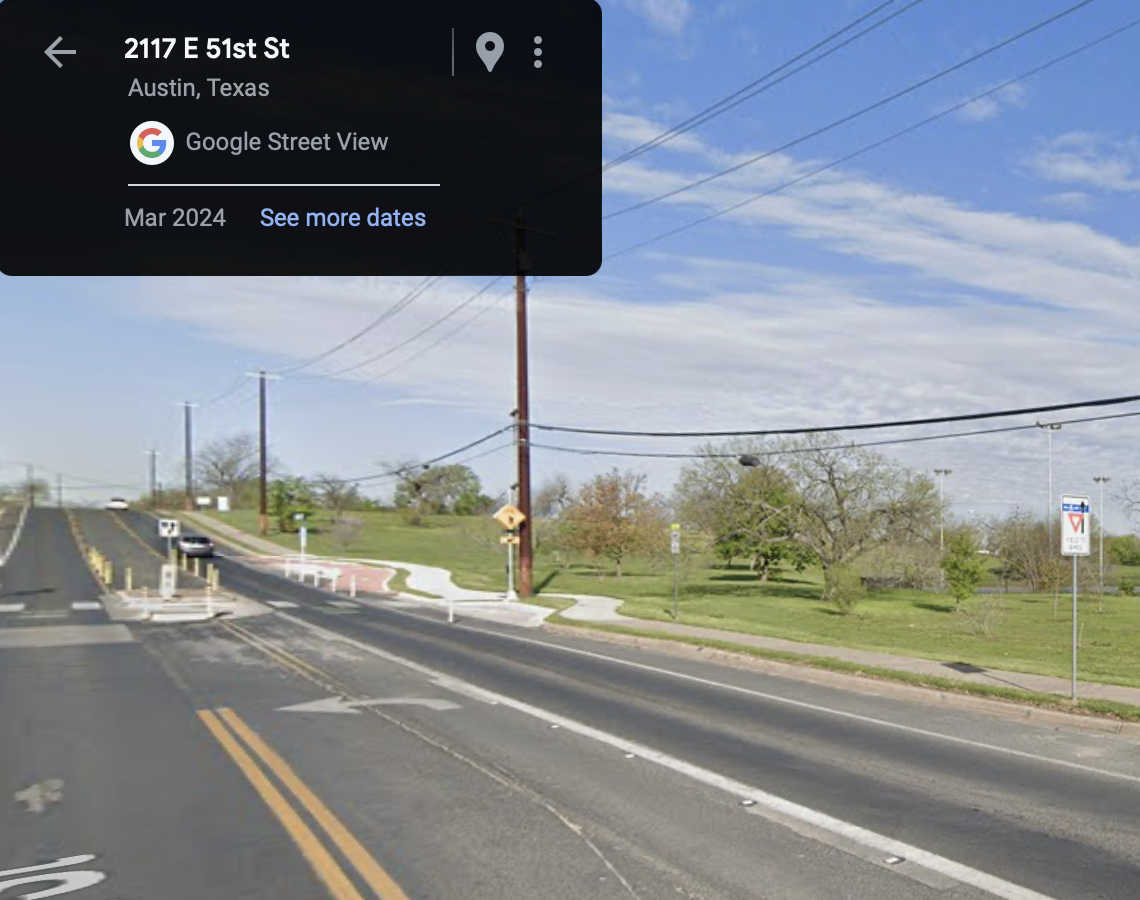
(The google vehicle was on the eastbound lanes but hopefully this is enough to show a standard ramp up to a red sidewalk, runs behind a bus stop, then ramps back to the on-street bike lane shortly after)_.
Despite the fact that my preexisting bias is to hate these, I don’t mind this one at all. Why? Speed differential. At this point on this uphill, I, a moderate-speed urban cyclist, am going not much faster than pedestrian speed, and the cars are going 30-40 mph as typical. So the speed differential is high on the road; and on the sidewalk if there’s ever pedestrians, I’m not going much quicker than them.
So far so good. What about the other side?
Here’s the start on google, approaching from the west. Oddly enough the street view vehicle appears to be on the other side now (worse for both directions). Have cut/pasted and oriented as well as I can to make up for it but I took my own pictures this way too.

See it yet? That big downhill? I’m typically going ~25 mph on this stretch and I’m not the fastest in the lycra crowd. But even a kid’s going to go pretty fast down this hill. So what happens when you get here:

Or what about here, where you start to see a car pulling out across the red sidewalk:
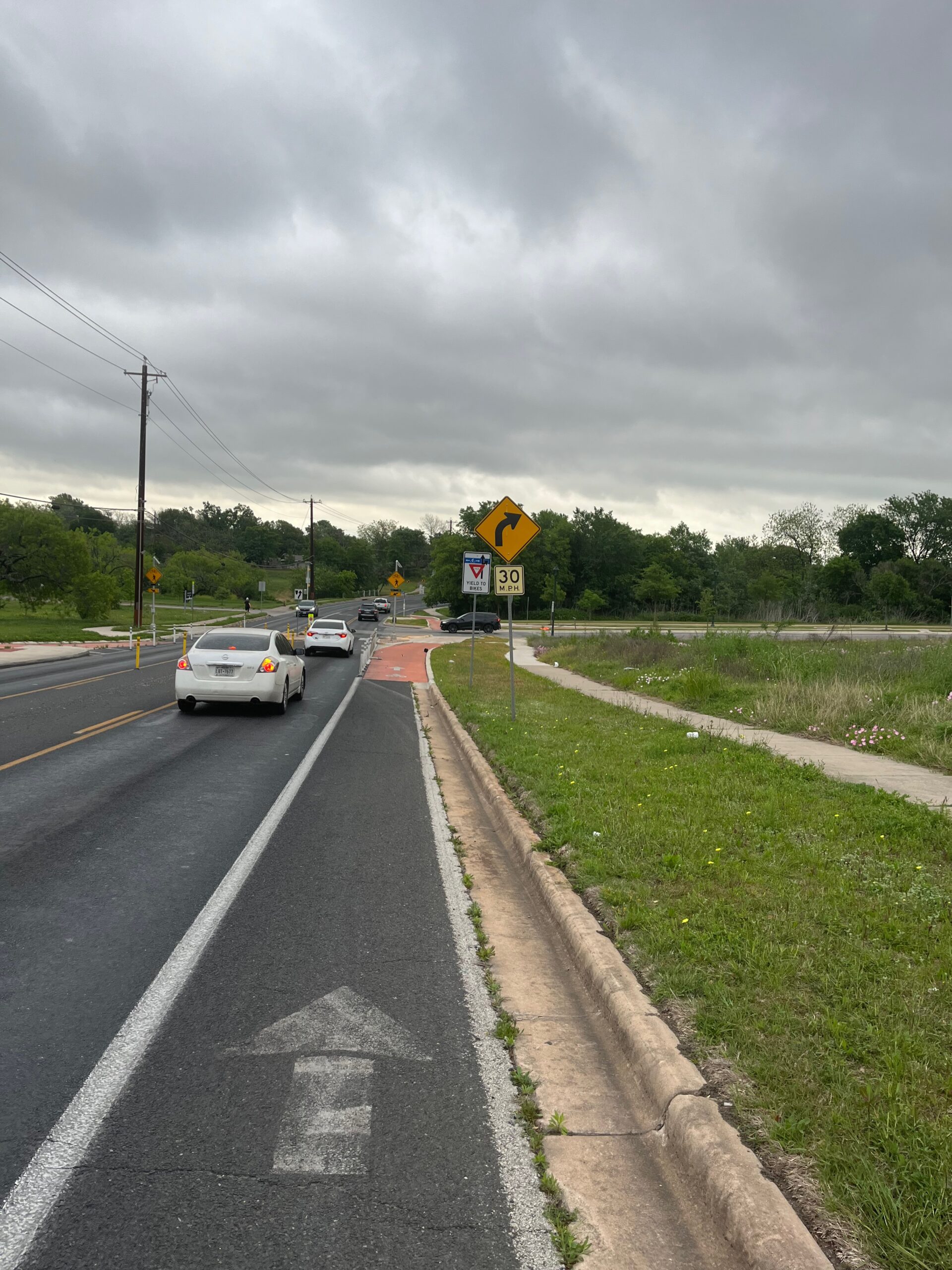
Should you wait until here to decide what to do?

Trick questions! The real answer is at the very top of the hill, you need to take the lane (which I am comfortable doing safety-wise, but always cognizant of it being bad PR, especially when there’s a brand new presumed expensive bike facility you’re seen not using). I have gotten honked at here, in other words!
What does a kid do, though? Is a kid going to know to take the lane at the top of the hill? The only other safe choice is to make sure to ride the brakes all the way down the hill so at the red sidewalk you’re only going the speed of a pedestrian, so you have time to stop for the car that will inevitably pull across the sidewalk to wait to turn.
“But M1EK,” you insist, “Surely cars won’t do that”.
I’ve ridden this road about a hundred times since I resumed cycling, and in about 30 of those times a car came to that stop sign to turn, and in exactly 100% of those times, the car pulled up to the edge of 51st St. Why? That’s the only real way they can tell they can make the turn safely. You aren’t going to change that normal driver behavior with signs like “Stop here” if they have to crawl forward to be able to see traffic. Just trust me, this is never going to happen.
And for people like me that will take the lane, you just made our lives worse too; because the existing downhill painted bike lane forces you onto the red sidewalk at the very bottom of a hill; so you have to commit very early to this maneuver, which increases car/cyclist conflict as at the top of the hill I’m only going 15, not the 25 I will be at the bottom.
“But that’s not the only intention for something like this”, you might say. “I’m willing to make things a little worse for experienced cyclists to help inexperienced cyclists feel comfortable and be safe”. So how likely is it that an inexperienced cyclist is going to know the right thing to do here? On this facility, which the city built precisely as part of the “All Ages & Abilities Network”, precisely to support inexperienced cyclists?
Think about it for a bit. I’ll be back with more, I promise.
Now for the normal stuff:
Comfort/pleasantness rating for adults: 8 (false comfort, on the eastbound side, but they’ll think they’re safe).
Perceived safety for AAA: 10 (again, false).
Actual safety for adult-speed cycling: 9 westbound, 0 eastbound
Actual safety for child-speed cycling: 9 westbound, 0 eastbound
How Right Was M1EK: 8 (I was too down on the north side and not down enough on the south side)
Encourages GOOD behavior: 0 (Kids and inexperienced adults will go too fast in the red lane eastbound)
on which I did my normal work commute which turned out to be too early for the 2 stations I planned to stop at; and now I wish I had stopped at the one at the AHC/old library with the nice people who were beckoning me to stop ↩